Murray to Mountains Rail Trail Map
The Murray to Mountains Rail Trail map is the ideal way to explore this amazing cycling trail in north east Victoria, Australia. Often referred to as 'Australia's best rail trail', the Murray to Mountains rail trail is relatively easy to navigate. It is well sign posted and the trail runs continuously from town to town.
The maps below are broken down into sections of the Murray to Mountains Rail Trail. Click each link below to see each section of the trail.
We also recommending reading our Ultimate Guide to the Murray to Mountains Rail Trail which includes more info such as accommodation, how to get there and where to eat and drink.
Murray to Mountains Rail Trail Maps
Wangaratta to Beechworth
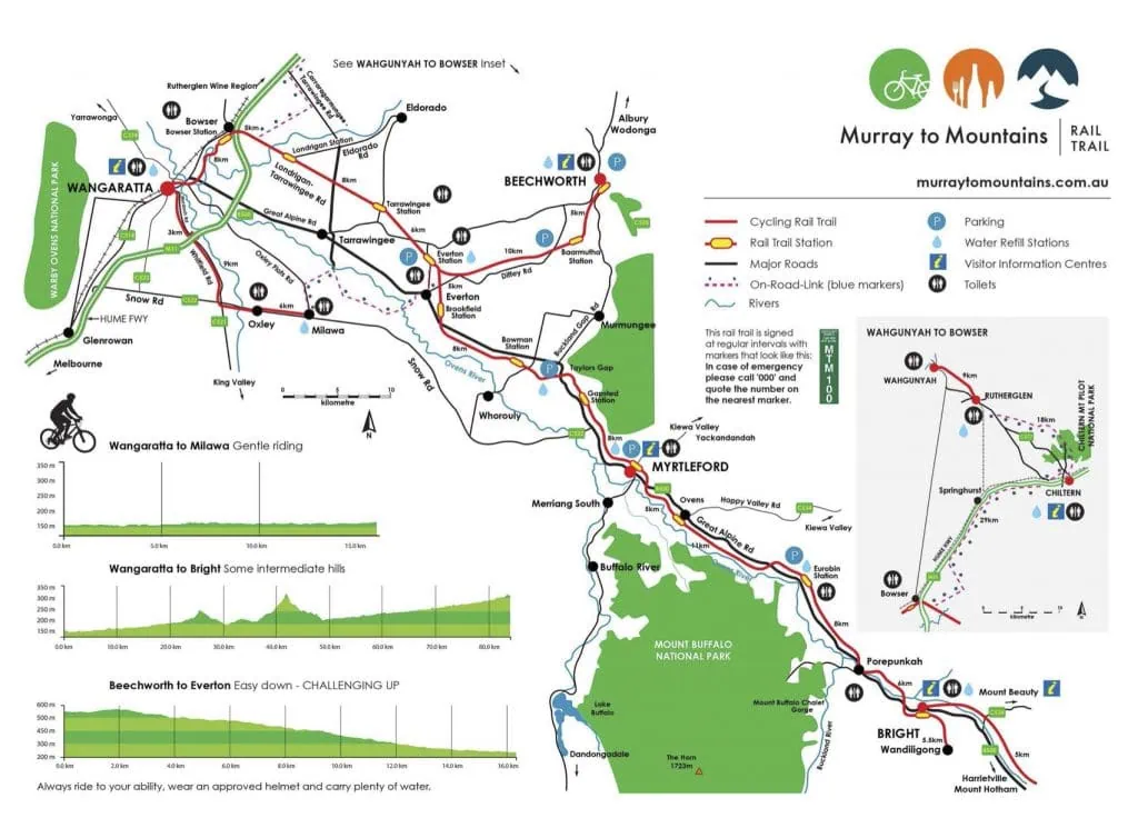
The Murray to Mountains Rail trail map (see bottom of this post) shows the trail starting in Wangaratta, heading east toward Bright. There is a fork at Everton that provides the option to head up the hill to Beechworth, or continue east to Bright. The hill up to Beechworth does require some effort, climbing over 300 meters over a 16km distance. It is a relatively straight path, with a constant gradient and has lovely rural views, bridges & vineyards. The uphill climb finishes at the historic and original Beechworth station. Alternatively you could start in Beechworth and roll down the hill! (as we do on all our cycling tours on the Murray to Mountains Rail trail). The total distance from Wangaratta to Beechworth is approx 43ms.
MAP LINK: Murray to Mountains Rail Trail: Everton to Beechworth
Wangaratta to Myrtleford
The alternative from Wangaratta is to bypass the hill up to Beechworth and continue straight to the next town of Myrtleford. In our opinion Beechworth is a gorgeous town and well worth visiting so we don't recommend this. There is still a hill (much smaller) to navigate on the way to Myrtleford. Referred to as Taylors Gap, this rise sits between Bowman Station and Gapsted. The rise is very gradual, gaining approx 150meters over a 5km stretch. The views once reaching the top are fantastic, all the way down the Alpine Valley and including the imposing My Buffalo.
MAP LINK: Murray to Mountains Rail Trail: Everton to Myrtleford
Myrtleford to Bright
This is possibly the prettiest section on the Murray to Mountains rail trail. Almost entirely flat, the trail passes underneath the striking Mt Buffalo as you head east to beautiful Bright. Mt Hotham and Mt Feathertop are in the distance, so there is a real Alpine feel to this region. From April to the end of May, the brilliant colours of autumn are in full display (see images from our blog post the Colours of Autumn around Bright). The rail trail heads all the way in to the centre of Bright, finishing at the main roundabout in the middle of town. If staying in Bright it would be handy to have a town map to assist navigating to your accommodation. Total distance is about 30kms.
MAP LINK: Murray to Mountains rail trail map: Myrtleford_to_Bright
The Complete Murray to Mountains Rail Trail Map
Murray to Mountains rail trail - The Towns
If you want to take the hassle out of cycling the Murray to Mountains rail trail, perhaps join a guided tour or enjoy a self guided tour on the rail trail with Tour de Vines. Check all the cycling tours on the Murray to Mountains rail trail, from 1 day to 5 days.